GIS Specialist & Remote Sensing Expert

Transforming geospatial data into actionable insights with 10+ years of expertise in GIS applications, remote sensing analysis, and spatial modeling solutions.

10+ Years Experience
20+ Projects Completed
95% Data Accuracy
GIS Software Interface

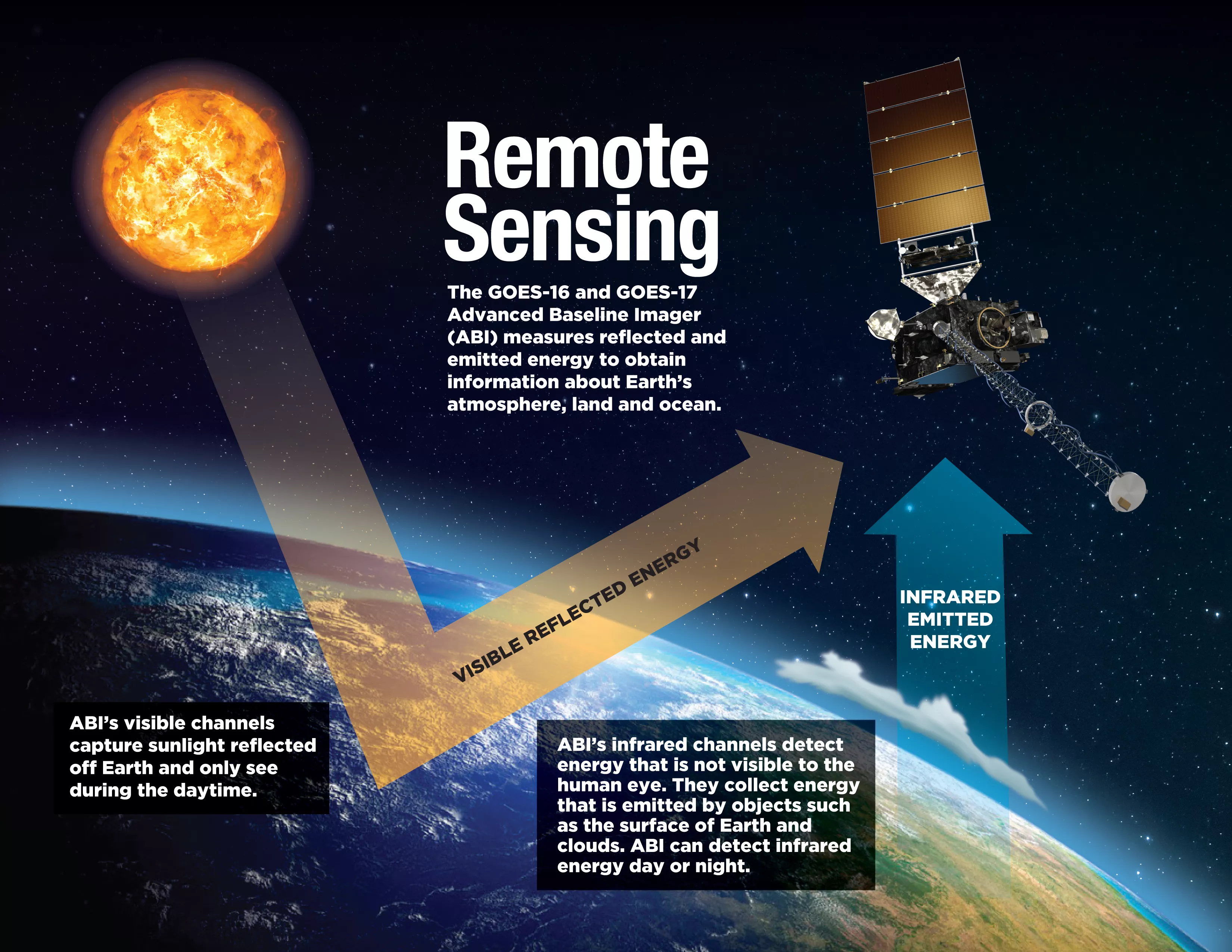
Advanced GIS Analytics

Spatial analysis & modeling

About Me

Professional Summary & Background

Experienced GIS Specialist and Remote Sensing professional with over 10 years of expertise in designing, implementing, and analyzing geospatial data and applications. Proficient in leading GIS software platforms including ArcGIS, QGIS, and Google Earth Engine, with a strong command of spatial analysis, cartographic visualization, and geospatial modeling.

Skilled in Python and SQL for automating workflows and managing large-scale geospatial databases. Demonstrated ability to lead GIS projects, collaborate with interdisciplinary teams, and deliver actionable geospatial solutions that support strategic decision-making.

Global Experience

Worked across US, Germany, Saudi Arabia, UAE, and Pakistan

Remote Sensing Expert

Advanced satellite imagery analysis and processing

Big Data Solutions

Managing enterprise geospatial databases for 50+ users

Satellite Data Analysis

Education & Certifications

Academic Background & Professional Training

Post Graduate Diploma in GIS & Remote Sensing

University of Peshawar

Department of Geography & Geomatics

Advanced Specialization

Master in Geography

University of Peshawar

Department of Geography & Geomatics

Master's Degree

Diploma in Artificial Intelligence

President Initiative for Artificial Intelligence

Advanced AI and Machine Learning Techniques

Professional Diploma

Diploma in Information Technology

Frontier Institute of Technology

Computer Science and Programming Fundamentals

Technical Diploma

Certificate in Land Survey

Khyber Institute of Technical Education

Surveying Techniques and Geospatial Measurements

Professional Certificate

Professional Experience

Career Journey & Key Achievements

2025 - Present

GIS Specialist

Zeerak Solutions, United States (Remote)

  • Designed GIS database improving spatial data retrieval time by 10% and reducing processing time
  • Integrated multi-source geospatial data from 3+ sources using Python and SQL, resulting in 20% increased analysis efficiency
  • Created interactive maps, 3D models, and dynamic visualizations with ArcGIS, QGIS, and web GIS platforms
  • Managed GIS servers and web services for real-time data sharing and application deployment
  • Collaborated with teams to ensure seamless integration of GIS solutions into enterprise projects
2024

GIS Data Expert

EU Tech Chamber, Germany (Remote)

  • Developed 6+ QA/QC protocols in Oracle Spatial Studio ensuring 99% geospatial data accuracy for Green Belt Project
  • Mapped soil moisture using Sentinel-2 SWIR bands and Google Earth Engine, identifying 5+ sites for wetland restoration
  • Performed hydrological modeling with HEC-RAS for flood simulation across 8 vulnerable catchments
  • Identified ecologically sensitive areas near infrastructure routes, recommending wildlife corridors
2020 - 2024

GIS & Remote Sensing Analyst

Planning & Development Department, KP Pakistan

  • Analyzed 30+ sq km of forest area using Sentinel-2 imagery, identifying 12 wildfire hotspots with 90% accuracy
  • Managed enterprise geospatial datasets supporting 50+ users across government departments
  • Implemented deep learning algorithms improving agricultural field pattern identification by 35%
  • Generated high-resolution DEMs with ±20cm vertical accuracy for infrastructure planning
  • Produced detailed thematic and topographic maps for 25+ planning applications
  • Converted 75+ GeoJSON and GML formats into Shapefile using Safe Software FME Desktop
2017 - 2020

GIS Developer

Ministry of Municipalities and Housing, Saudi Arabia

  • Developed 4+ web-based mapping tools increasing user engagement by 30%
  • Administered ArcGIS Enterprise and Online platforms supporting 18+ users
  • Automated GIS workflows using Python scripting, reducing processing time by 40%
  • Designed geoprocessing scripts improving QA efficiency by 25% for infrastructure datasets
  • Converted 100+ AutoCAD and MapInfo files into ArcGIS-compatible formats
  • Configured ODK and QField for field data collection, improving accuracy by 35%
2015 - 2017

Geomatics Engineer

Ministry of Municipalities and Housing, Saudi Arabia

  • Created 8+ topology rules for data inspection of 10,000+ GIS asset records
  • Applied qualitative and quantitative methods for spatial data analysis across 6 municipal districts
  • Conducted watershed delineation in Arc Hydro across 1,500+ sq km for flood risk analysis
  • Designed utility networks for electricity, water, and telecom infrastructure spanning 100+ km
  • Created 3D models of 4+ municipal buildings in City Engine for urban planning
  • Collected ground-truth data using surveying equipment for 100+ spatial data points per project
2014 - 2015

GIS Associate

Department of Geography, University of Peshawar

  • Developed baseline standardized datasets for 5+ line directorates, improving accessibility by 25%
  • Collected and verified 200+ GPS coordinates using ODK Android application with 90% accuracy
  • Compiled topographic sheets and contour maps for 8-line directorates
  • Digitized 20+ cadastral maps into 8 distinct land use categories
  • Digitized 10+ geological and soil maps of FATA region covering 27,000 sq km

Key Projects

Featured Work & Achievements

Green Belt Project

Green Belt Project - Saxony, Germany

Developed comprehensive QA/QC protocols ensuring 96% geospatial data accuracy across 177 sq km for environmental restoration initiative.

Oracle Spatial QA/QC Environmental
Forest Wildfire Analysis

Forest Wildfire Hotspot Analysis

Analyzed 30+ sq km using Sentinel-2 imagery and Google Earth Engine, identifying 12 wildfire hotspots with 95% accuracy for $1M rehabilitation initiative.

Google Earth Engine Sentinel-2 Fire Analysis
Red Sea Project

Red Sea Project GIS Database

Developed comprehensive GIS database integrating 17+ data layers across 200+ sq km for major development project in Saudi Arabia.

ArcGIS Database Design Urban Planning
FTTH Network

Fiber to Home Network Design

Designed outside plant network facilities for FTTH projects covering 11+ neighborhoods with 5,000+ potential connections in Saudi Arabia.

Network Design Telecommunications Infrastructure
SignalSpace Project

SignalSpace™ Thermal Anomaly Detection

Backtesting cryogenic thermal anomalies and visual blackout signals over biotech sites using satellite data, correlating with stock price movements (REGN, PFE, JNJ).

GHGSat Sentinel Financial Analysis
SAR Flood Analysis

SAR-Based Flood Inundation Mapping

Utilized Sentinel-1 SAR imagery to determine flood-prone areas, created DEM, slope, aspects mapping, and flood inundation analysis with change detection capabilities.

Sentinel-1 SAR GEE/SNAP Flood Mapping
Real Estate GIS Database

Real Estate GIS Database - DL King

Established comprehensive GIS database of real estate units, integrating open-source and public government datasets with multi-layer overlays for proximity analysis.

Real Estate Database Integration Proximity Analysis
Riverbank Erosion Analysis

Riverbank Erosion Analysis - Liquid Trees

Conducted riverbank erosion analysis using time-series satellite imagery, quantifying 23 km of affected shoreline with 92% model accuracy and assessed dissolved CO₂ concentrations.

Time-series Analysis Sentinel-3 Environmental Monitoring
T5 Dam Infrastructure

Digital Terrain & Risk Mapping/Planning

Generated high-resolution Digital Elevation Models with vertical accuracy of ±20cm for critical infrastructure planning and flood risk assessment.

DEM Generation Infrastructure Flood Risk

Technical Skills

Core Competencies & Technologies

GIS Applications

ArcGIS 10.8/Pro
ArcGIS Online/Enterprise
PostGIS
MapInfo & Global Mapper

Remote Sensing & Image Analysis

Google Earth Engine (GEE)
ENVI & QGIS
SNAP & Pix4Dmapper
Agisoft, GDAL, Rasterio

GNSS & UAV Platforms

Trimble R8
SatLab SL700
LiVOX LiDAR
DJI Matrice 300 RTK

Web GIS & Frameworks

ArcGIS API for JavaScript
Leaflet & OpenLayers
GeoDjango
Spatial ETL/FME

Other Applications

Tableau & PowerBI
AutoCAD
Microsoft Office / 365
Photoshop

Programming & Web Technologies

Python & JavaScript
HTML5 & CSS3
React & Dojo Frameworks
ArcGIS Web AppBuilder/ModelBuilder

Database Tools

PostgreSQL/PostGIS
Microsoft SQL Server
Oracle Spatial

Get In Touch

Let's discuss your geospatial needs

Email

saeedkhanzeerak@gmail.com

Phone

+1-302-532-3627

LinkedIn

linkedin.com/in/saeedkhanzeerak

GitHub

github.com/saeedkhanzeerak